Coast Guard Re-establishes Storm Flag Program
CMDR Jeff Carter USCG Chief of Media RelationsThe U.S. Coast Guard has announced it is re-establishing a Coastal Warning Display (Storm Flag) program at selected Coast Guard boat stations throughout the U.S to warn the public of approaching storm conditions.
Coast Guard stations participated in the National Weather Services official Coastal Warning Display program for over 100 years along with yacht clubs and marinas, until it was discontinued in 1989. "For everyone living along the coast these storm flags serve as a visible reminder of the destruction that can be wrought by nature, especially as we head into this years hurricane season," said Rear Adm. David Pekoske, assistant commandant for operations.
According to the National Oceanic and Atmospheric Administrations "Population Trends Along the Coastal United States: 1980-2008," the narrow coastal fringe that makes up 17 percent of the nations contiguous land area is home to more than half of its population. In 2003, approximately 153 million people (53 percent of the nations population) lived in the 673 U.S. coastal counties, an increase of 33 million people since 1980.
"Storm flags are a nautical tradition for mariners, and the Coast Guard is pleased to bring back this part of our maritime heritage (Figure 1). However, the real message is that as the flags indicate changing weather from gale to storm to hurricane conditions, everyone, not just mariners, must tune in to National Weather Service broadcasts and start thinking what they will do to prepare for the worst. The power of nature cannot be underestimated. These nautical flags are intended to visually communicate to the American public the lesson of past hurricanes to take personal responsibility for individual safety in the face of an approaching storm," said Capt. Jim McPherson, the Coast Guards chief of public affairs.
Starting June 1, selected boat stations will hoist display flags to warn of small craft advisories, gale warnings, storm warnings, and hurricane warnings. Residents of coastal communities are urged to tune to National Weather Service radio broadcasts for the latest information when they observe a flag hoisted as part of this program. The flags are not intended to preclude mariners from taking necessary precautions as soon as possible to protect their vessel and crews.
Mariners are encouraged to visit www.uscg.mil/news/stormcenter/ for suggestions on how to prepare their vessels ahead of a storm.
Since 1871, the Coast Guard has responded to over 70 major storms and saved nearly 300,000 people. During Hurricane Katrina, Coast Guard helicopter and boat crews rescued over 33,000 people.
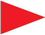

Small Craft Advisory
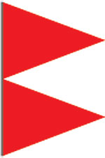
Gale Warning
Storm Warning
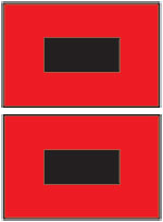
Hurricane Warning
Figure 1. Storm flags indicate changing weather from small craft to hurricane conditions. For specific wind criteria due to geographic concerns, visit:http://www.nws.noaa.gov/om/marine/faq.htm#13
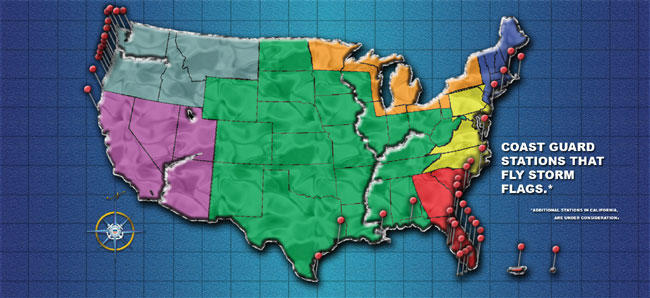
Figure 2. USCG CWD Stations
| Station Name | State | District | ||
|---|---|---|---|---|
| Chatham | MA | 1 | ||
| Merrimack River | MA | 1 | ||
| Shinnecock | NY | 1 | ||
| Atlantic City | NJ | 5 | ||
| Little Creek | VA | 5 | ||
| Wrightsville Beach | NC | 5 | ||
| Brunswick | GA | 7 | ||
| Charleston | SC | 7 | ||
| Cortez | FL | 7 | ||
| Fort Lauderdale | FL | 7 | ||
| Fort Meyers | FL | 7 | ||
| Fort Pierce | FL | 7 | ||
| Georgetown | SC | 7 | ||
| Islamorada | FL | 7 | ||
| Key West | FL | 7 | ||
| Lake Worth Inlet | FL | 7 | ||
| Marathon | FL | 7 | ||
| Mayport | FL | 7 | ||
| Miami Beach | FL | 7 | ||
| Ponce De Leon | FL | 7 | ||
| Port Canaveral | FL | 7 | ||
| San Juan | PR | 7 | ||
| Sand Key | FL | 7 | ||
| St Thomas and St Croix | USVI | 7 | ||
| St.Petersburg | FL | 7 | ||
| Tybee | GA | 7 | ||
| Yankeetown | FL | 7 | ||
| Destin | FL | 8 | ||
| Galveston | TX | 8 | ||
| New Orleans | LA | 8 | ||
| South Padre Island | TX | 8 | ||
| Noyo River | CA | 11 | ||
| Bellingham | WA | 13 | ||
| Cape Disappointment | WA | 13 | ||
| Chetco River & Rogue River | OR | 13 | ||
| Coos Bay & Coquille River | OR | 13 | ||
| Depoe Bay | OR | 13 | ||
| Grays Harbor | WA | 13 | ||
| Neah Bay | WA | 13 | ||
| Port Angeles | WA | 13 | ||
| Quillayute River | WA | 13 | ||
| Siuslaw River | OR | 13 | ||
| Tillamook Bay | OR | 13 | ||
| Umpqua River | OR | 13 | ||
| Yaquina Bay | OR | 13 | ||
Editors Note: The National Weather Services Coastal Warning Display program was de-emphasized in favor of frequently updated telephone recordings (Table 1) and NOAA Weather Radio frequencies (Table 2). The latter covers the coastal areas of continental United States, Alaska, Hawaii, and the Mariana Islands with continuous weather broadcasts. These notification programs are able to reach a larger portion of the marine public. As such, please listen to NOAA Weather Radio when you see the warning flags flying for specific information on movement, intensity, and duration.
Table 1. Marine Forecast Telephone Warning Recording List
| National Weather Service Phone Recordings of Marine Forecasts | |
| Dial-A-Buoy | 888-701-8992 |
| Ocean Prediction Center | None available |
| PCBU | 17/1200 |
| Tropical Prediction Center | None available |
| National Hurricane Center | None available |
| Central Pacific Hurricane Center | None available |
| Caribou, ME | None available |
| Portland/Gray, ME | 207-688-3210 |
| Taunton, MA | 508-822-0634 |
| New York, NY | 631-924-0517 |
| Philadelphia/New Jersey | 609-261-6600 |
| Washington, DC/Maryland | 703-260-0107 |
| Wakefield, VA | 757-899-4200 |
| Newport/Morehead City, NC | 252-223-5737 |
| Wilmington, NC | 910-762-4289 |
| Charleston, SC | 843-744-0303 |
| Jacksonville, FL | 904-741-4370+ |
| Melbourne, FL | 321-255-0212# |
| Miami, FL | 305-229-4550 |
| Key West, FL | 305-295-1316 305-295-1316 Ext 241@ |
| San Juan, PR | 787-253-4586 787-253-4586 Ext 241@ |
| Tampa, FL | 813-645-2506 |
| Tallahassee, FL | 850-942-8851 |
| Mobile, AL | None available |
| New Orleans, LA | 504-465-9215 |
| Lake Charles, LA | 337-477-5285* |
| Houston/Galveston, TX | 281-337-5074 |
| Corpus Christi, TX | 361-289-1861 361-289-0959 Ext 1@ |
| Brownsville, TX | 956-504-1432 |
| Buffalo,NY | 716-565-0802 |
| Cleveland,OH | 216-265-2370# |
| Detroit/Pontiac,MI | 248-620-2355 |
| Gaylord, MI | 989-732-6242 |
| Grand Rapids,MI | 616-949-4253 |
| Grand Rapids,MI (alt) | 231-727-4009 |
| Chicago,IL | 815-834-0675 |
| Milwaukee/Sullivan,WI | 414-744-8000 |
| Green Bay,WI | 920-494-2363# |
| Marquette,MI | 906-475-5212@ |
| Duluth,MN | 218-729-6697 |
| Seattle, WA | None available |
| Portland, OR | 503-861-2722 |
| Medford, OR | 541-776-4305 |
| Eureka, CA | 707-443-6484@ |
| San Francisco, CA | 831-656-1725 |
| Los Angeles/Oxnard, CA | 805-278-0760 |
| San Diego, CA | 858-675-8700 |
| Juneau, AK | 907-790-6850 |
| Anchorage, AK | 907-266-5145 |
| Fairbanks, AK | 907-458-3745 |
| Hawaii-Marine Forecast | 808-973-5286 Ext 237*@ |
| Hawaii-Coastal Winds and Buoy Observations | 808-973-6114 + |
| Hawaii-Oahu Marine Forecast | 808-973-4382 |
| Hawaii-Oahu Surf Forecast | 808 973 4383 |
| Hawaii-Maui Marine Forecast | 808-877-3477 |
| Hawaii-Kaua`i Marine Forecast | 808-245-3564 |
| Hawaii-Hilo Marine Forecast | 808-935-9883 |
| Marianas (Guam) | 211(Guam only) 671-472-0952*@ |
| The Republic of Palau | 680-488-1103 671-472-0952@ |
| Micronesia - Yap State | 691-350-2443 671-472-0952@ |
| Micronesia - Chuuk State | 691-330-4349 671-472-0952@ |
| Micronesia - Pohnpei State , TX | 691-320-5788 671-472-0952@ |
| Micronesia - Kosrae State | None available 671-472-0952@ |
| The Republic of the Marshall Islands | 692-625-3079 671-472-0952@ |
| Samoa | None available |
* Answered by forecaster
@ Forecaster available for further assistance
+ Forecaster available for further assistance 9am-5pm
Table 2. NOAA Weather Radio Frequencies
| 162.400 | 162.425 | 162.450 | 162.475 | 162.500 | 162.525 | 162.550 |